

THURSDAY, MAY 2, 2019
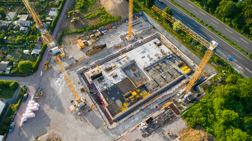
A draft solicitation has recently been issued for the development of an analytics tool that would be able to detect large-scale construction projects and other “anthropogenic activity” worldwide.
The offer was submitted by the U.S. Director of National Intelligence’s Intelligence Advanced Research Projects Activity office, and is part of the agency’s Space-Based Machine Automated Recognition Technique program.
The idea is being considered as a way to relieve human analysts from mountains of data.
Tool Necessities
When contemplating development of the new tool, the need for a broad-area search functionality is one of the biggest concerns. According to the drafted solicitation, the system would have to be able to stitch together various images from the U.S., foreign and commercial satellites and pair them with archived data, environmental factors and weather patterns, which might affect image quality.
|
|
| ollo / GettyImages |
|
A draft solicitation has recently been issued for the development of an analytics tool that would be able to detect large-scale construction projects and other “anthropogenic activity” worldwide.   |
The tool would also need to have image processing technology for drones and miscellaneous aircraft. By collecting data through the mentioned processes, the advanced analytics tool would be able to track how a construction site changes over time.
“The volume of [geospatial intelligence] continues to grow, while analysts struggle with the volume, variety and velocity of space-based data to support local, regional and national decision-making,” IARPA officials wrote in the draft broad agency announcement.


“SMART seeks to bridge an expertise, infrastructure and data preparation gap by developing easy-to-implement tools for [geospatial intelligence] analysts to efficiently analyze, assess and utilize big data.”
What’s Happening Now


With the Intelligence Community planning to invest “tens of billions” of dollars in commercial cloud capabilities, the drafted program is slated to run in three phases and will take four years to complete.
Officials at IARPA are already suggesting that interested vendors should make sure that they have the capability to integrate their information into a cloud environment.


IARPA will also be accepting suggestions and questions about the grant project until May 10, when it will then issue a formal funding offer.
Tagged categories: Construction; Digital tools; Good Technical Practice; Government; Grants; Information technology; Technology; Tools & Equipment - Commercial

